On Monday, after he was characteristically late arriving to start an already rushed adventure, Molly and I joined him for a late night drive to drop a vehicle off in Jenkinsburg, where Big Sandy Creek meets the Cheat River. After that, we drove in a second vehicle to Rockville. It was past 11 pm when we finally got the the beginning of our trip, which would last only about 13 hours. And, it was was a seriously concentrated 13 hours.
To whitewater paddlers, Jenkinsburg is a familiar place because it is the take out point for these two classic runs and Rockville is a popular put in. And, though Rockville and Jenkinsburg may have the sound of established towns on some main road, perhaps with a few residents or businesses, they are not. As is the case with many places in Appalachia where the coal industry temporarily created a small community, the only evidence of civilization in both of these "towns" are old dirt and gravel covered mountain roads, a bridge, and a few misleading specs on the dated USGS map of the area. If you ask Google Maps for either town, you get rubbish for Jenkinsburg and a random point about five miles away for Rockville. Given the nature of our journey, this is poetry.
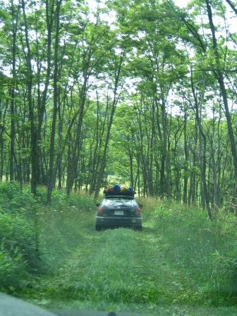
They were calling for rain. That's why we felt a bit rushed as we left the car to start the walk to Wonderfalls. We packed light for one night in the woods and only one substantial meal, so it didn't take us long to hit the trail. That is, it wouldn't have taken us long. However, Allegheny Wood Products, the owner of the forest (aka, timber) that is currently holding the ground together, has taken the first 3/4 of our trail and widened it into a road for its heavy machinery. We begrudgingly began to walk down this road in the trail's stead.
As if slogging down a 30 foot wide road of gravel-laced mud several inches thick wasn't miserable enough, the sight of large
 earth-moving, tree-digging vehicles brought our initial spirits to a minimum.
But, Jeremy got to drive the bulldozer (lemonade!).
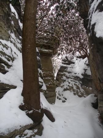
With the road-making equipment behind us, our unseasonably warm night hike into Wonderfalls became much more enjoyable. We mindfully scoped out a place to pitch our tent that would hopefully be void of runoff from the predicted showers, eventually settling for a tree-covered spot about 50 feet above the falls and just off the riverbank. We were very glad to find that the tent held out all of the water because the showers most definitely materialized. A quick breakfast and coffee in the morning mountain fog got us rearing to move. So, we did.
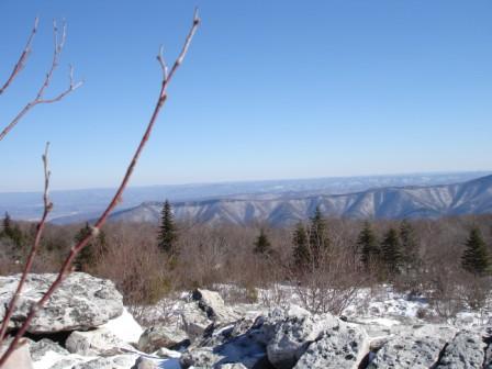
Given that we were technically trespassing on our adventure, there were no trails. Navigation would instead be guided by a network of overgrown, long forgotten logging roads, the creek's deep canyon, and, ultimately, the far off sight of Cheat Canyon's steep walls that were blue with mountain haze.
We pushed through waist-high underbrush, wrestled our way through complicated ruins of downed trees, and scaled up and down loose, rocky sections of the canyon, all the while knowing that the car at the end of our journey was across the creek and there was no bridge. At some point, we'd be faced with finding a crossing. Secretly, I think that it was precisely this prospect that initially attracted both me and Jeremy to this trip.
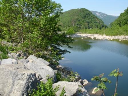
After a few hours of travel, from a point high above the creek, we came to the decision that it was time to cross. As if we actually knew what we were doing, after descending into the canyon we arrived at the creek exactly where we'd
 hope we would. A bridge once crossed Big Sandy Creek here and three of the concrete supports are still there. This meant that had we crossed any further down the canyon, we'd have to ascend the steep walls to get to an old road bed and had we crossed further up the canyon, we'd have had to boulder-hop on the other side of the creek until we came to this point. It could not have been planned more effectively, with strong sarcasm underlying plan.
Crossing the creek was the trip's major obstacle. After over an hour of effort, our party of three adults and our three heavy packs had made it across, our lower extremities spending minimal time in the water. It was a game of Twister played in the roar of mild whitewater, shouting commands and encouragement to each other the entire time. The creek is about 25 feet wide where we crossed, and the boulders and shallow sections required about 5 or 6 moves and two or three of them were really tricky.
Allright. Put your right knee here on this rock and let your right foot dangle into the water until you find the rock to stand on. It's about 8 inches down. Okay, can you take your left arm and reach way out to grab that far rock? Nice! Now, reach across the deep part with your left leg and stand up on the rock that's just beneath the surface of the water. Watch it; that rock's slippery! Take your time! Nice work. Now, grab that first pack and toss it to me. Ready? Okay, on three; one, two, THREE! Good throw! Okay. I'm going to jump to that rock. Will you be able to grab me if I lose my balance?
I consider that creek crossing to be what made our trip down the Big Sandy epic. I've had one other truly epic hike in my life and it occurred in Shenandoah National Park, but that's not in West Virginia.
 Once across the creek, it was about a mile and a half down the well-worn old road. Downed trees and evidence of landslides got in our way at a few times, but the elation of completing the journey was realized as soon as we were safely looking back nostalgically at our hairy crossing. Continuing, we knew we were near the car and in the vicinity of a swimming hole of overwhelming local popularity when we passed a very peculiar sign .
We got to the car reeking heavily of accomplishment. A man and woman sat on the tailgate of their pickup in Jenkinsburg drinking Natural Light. He asked us if we'd seen any wildlife. No, we told him, unfortunately it was an uneventful hike from Rockville. He asked us why in the world we walked that far through the woods, and I didn't tell him that it was because people like him don't. He told us to stick around and he'd show us some of the wildlife we failed to encounter. But, I had to get to work.
Enjoy the photos.
Git 'r dun.